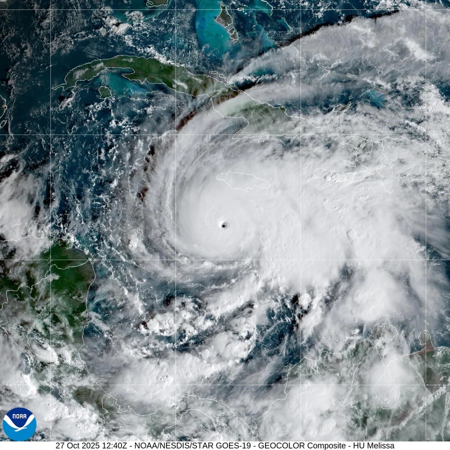
While the least intelligent among us continue to deny the reality of climate change, one of the most powerful Atlantic hurricanes ever recorded is currently unleashing devastation on the Island of Jamaica and will continue on to Cuba.
Hurricane Melissa, which struck Jamaica with record-tying 185 mph winds Tuesday, was a beast that stood out as extreme even in a record number of monster storms spawned over the last decade in a superheated Atlantic Ocean.
Melissa somehow shook off at least three different meteorological conditions that normally weaken major hurricanes and was still gaining power as it hit, scientists said, a bit amazed.
And while more storms these days are undergoing rapid intensification — gaining 35 mph in wind speed over 24 hours — Melissa did a lot more than that. It achieved what’s called extreme rapid intensification — gaining at least 58 mph over 24 hours. In fact, Melissa turbocharged by about 70 mph during a 24-hour period last week, and had an unusual second round of rapid intensification that spun it up to 175 mph, scientists said.
“It’s been a remarkable, just a beast of a storm,” Colorado State University hurricane researcher Phil Klotzbach said.
Melissa ties records
When Melissa came ashore it tied strength records for Atlantic hurricanes making landfall, both in wind speed and barometric pressure, which is a key measurement that meteorologists use, said Klotzbach and University of Miami hurricane researcher Brian McNoldy. The pressure measurement tied the deadly 1935 Labor Day storm in Florida, while the 185 mph wind speed equaled marks set that year and during 2019’s Hurricane Dorian. Hurricane Allen reached 190 mph winds in 1980, but not at landfall.
Usually when major hurricanes brew they get so strong that the wind twirling in the center of the storm gets so intense and warm in places that the eyewall needs to grow, so a small one collapses and a bigger one forms. That’s called an eyewall replacement cycle, McNoldy said, and it usually weakens the storm at least temporarily.
Melissa showed some signs of being ready to do this, but it never did, McNoldy and Klotzbach said.

Another weird thing is that Melissa sat offshore of mountainous Jamaica for awhile before coming inland. Usually mountains, even on islands, tear up storms, but not Melissa.
“It was next to a big mountainous island and it doesn’t even notice it’s there,” McNoldy said in amazement.
Warm water is the fuel for hurricanes. The hotter and deeper the water, the more a storm can power up. But when storms sit over one area for awhile — which Melissa did for days on end — it usually brings cold water up from the depths, choking off the fuel a bit. But that didn’t happen to Melissa, said Bernadette Woods Placky, chief meteorologist for Climate Central, a combination of scientists and journalists who study climate change.
Breathtaking and at the same time terrifying footage from inside the eye before landfall was captured

